Hawkesbury Upton to Wotton-under-Edge - Monday 20 May 2019
Our continuation of the
Cotswold Way had been planned for some time and “set in stone”. Arrangements
were to meet up on the “usual” train at Didcot and make our way to Yate. With
regret N had to bow out at the last moment, in fact turning up at Oxford station
to tell A that he couldn’t make it. Therefore it was just the three of us who
made our way to Yate bus station (Grid Ref: ST7166 8239). Without going into
personal detail we realised we all had some form of ailment that day. We were
pleased to hear later on in the day that N was on the way to recovery.
 |
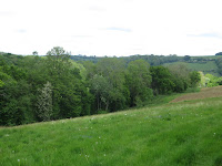
| Claypit Woods near Hawkesbury Upton |
We had about 35 minutes to
wait for the bus to Hawkesbury Upton so we popped across the road and had
coffee /tea and pastel de nata in Esquires Coffee (ST7172 8243). We eventually rolled up in HU at 12:20.
It was an excellent weather
day for walking, sunny, cool wind and dry. We passed the Somerset monument
(ST7723 8765) again and soon got into our stride.
 |
| Wild garlic |
Our route passed through
attractive woodlands full of the perfume of wild garlic. Is it a perfume? Perhaps
to some it is a stench or a smell. However you want to refer to it the scent is
certainly distinctive and conjures up memories of wooded hillsides in the spring.
The route criss-crossed the
Monarch’s Way as we passed one small hamlet after another. Most of these seemed
to be based around the site of old water mills, e.g. Curtis Mill, Lower
Kilcott; Kilcot Mill; Newmills Farm; Hillsley Mill, Alderley. Presumably founded
on streams emerging from the foot of the Cotswold scarp.
 |
| Ponies near Alderley - what breed? |
We passed several walkers
and one party of ten walkers all heading south. We have seen more walkers on
this route than on any other long distance walk. They all seemed cheerful.
We reached the hamlet of
Alderley and were starting to get peckish it was 1:30pm. We agreed to carry on
to find a view but regretted that decision when we started to climb up Wortley
Hill by means of a sunken lane.
 |
| Plenty of wild flowers on display |
The climb was fairly steep and our range of
ailments meant we needed to take it slow. We eventually found a grassy bank
near the summit and thankfully took a break for lunch and water, (ST7728 9229).
After the much needed rest
we carried on through the mixed woodland, passing another walking group. The
path took a sudden turn downslope, so steep that steps had been cut in the
slope. We could see the Somerset monument, near where we started. Oh dear we
don’t seem to have come very far. Further southwest we could make out the towers of
both suspension bridges across the River Severn and perhaps a faint blue smudge
of the Brecon Beacons (?) over to the West.
 |
| View to the Severn (can't see the bridges though) |
We carried on, more
walkers, more docile cattle (pleased about that). We then joined the lane
towards Wotton (according to the map this is known as Blackquarries Hill). The
road became steeper and then the Cotswold Way path descended an even steeper
slope down through the woods to the hamlet of Coombe. On the way we disturbed a
badger, which didn’t hang around. Unusual to see them out during the day. We
reached the valley bottom and made our way into Wotton-under-Edge.
A short wait for the bus back to Yate station, which took about 40 minutes. We thought we had missed the train, but no, it was late so no particular wait in Yate, though we did miss the connection at Bristol Parkway!
A short wait for the bus back to Yate station, which took about 40 minutes. We thought we had missed the train, but no, it was late so no particular wait in Yate, though we did miss the connection at Bristol Parkway!
Comparing notes afterwards
we all seem to have got to our respective homes sometime after 7pm.
Looking at the timings we started at 12:20 and
finished at 16:20; an afternoon ramble of four hours with a late lunch break.
It was wonderful to be in the Cotswolds again though we all need to get fit for
the next stage (17 June), which has two steep climbs! Great weather and lovely
views. We measured the distance covered on this stage as 7.2 miles (11.6km).
No comments:
Post a Comment