Monday, 14 April 2014

The Seven Shires Way - Stage 15


Chilton to Fawley, Friday 21 March 2014


Skylark country
As explained in the last post we have jumped ahead to the Berkshire Downs while the River Thames gets back to normal. We also agreed that as we had already walked some of the Ridgeway we could join the path some way on at Scutchamer Knob (Grid Ref: SU45828501). This also worked out well for the buses. We met at Didcot Station, N was already on the X32 from Oxford and P&T joined him at Didcot. The bus took us up to Fermi Avenue, Harwell Campus (Grid Ref: SU48108668) and we set off at 09:40 to walk up to Ridgeway past a new housing development at Chilton. The aim of the walk was to get to Fawley (Berkshire).

View north from Scutchamer Knob
At long last a warm-in-the-Sun, cold–in-the-wind sort of day. Looks like Spring is here (well it is the equinox). Good views all around to the north past the Rutherford-Appleton Laboratory and its old Nimrod facility and its new Diamond Light Source towards the distant Chilterns and the communications tower at Aston Hill that we walked past in the autumn of 2013 (see Stages 12 (15 November) and 13 (6 December 2013)). The sky had started off clear blue but was now filling with cumulus clouds. P said that rain was forecast at 13:00. We reached the Ridgeway near to Scutchamer Knob and stopped for a first sandwich of the day and a swig of coffee to enjoy the view over the sites of Pluto and Dido (nuclear research reactors) towards Abingdon and Oxford. General discussion about knobs and knolls and T remembering family picnics up here. 

Knollend Down
We then decided to cut down Knollend Down to Lands End (Grid Ref: SU44778325) as the path actually stayed closer to the county boundary than that taken in the book. Great views to the south and plenty of Skylarks in the arable fields. A steady climb up the hill on “Old Street” still heading south past a tractor spraying something on a field. (We were later to be told that this was likely to have been liquid fertiliser on a field of spring barley). Then near the top of the hill we turned west to head towards the village of Farnborough (Berkshire) and views of Wether Down to the north (the path recommended in the book).

Wether Down (the path untrodden)
Farnborough Old Rectory - Haha
Farnborough is another of these quaint villages of old houses “Old Smithy”, Old Rectory”, Old Post Office” or some such now much improved and sporting electric gates and security cameras. We popped into the church, All Saints (Grid Ref: SU43538194), as the west window is a modern stained glass memorial to Sir John Betjeman who used to live in the Old Rectory behind his Ha-Ha (far from the bombs raining down on Slough – ha ha!). The window was colourful and P was sure that there was an image of HS2 on it cutting though a depiction of the English countryside.
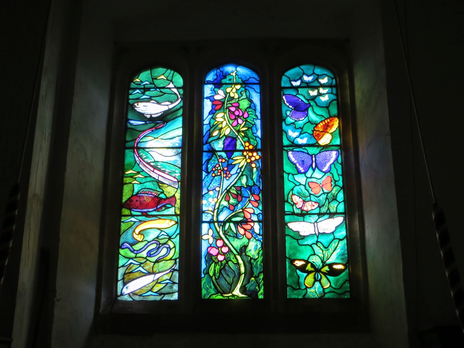
West window, All Saints Church


As you will have guessed there is no pub in Farnborough though we are sure there must be an “old something pub” somewhere in the village. 

Coombe Lodge (new)
“Let’s push on chaps and find a spot for lunch”.  Carried on westwards towards the B4494 (Newbury to Wantage) and crossed said road near Coombe Lodge (Grid Ref: SU42188212). Another new build house just like the Georgian style Well Barn we discussed in the last post (28 February). Research by P later found that the West Berkshire planning records are less forthcoming than South Oxon, however the original farm and building were knocked down in the mid noughties and this new imposing place constructed.
Winterdown - typical downland countryside

It was now one o’clock and yes it started to rain and hail so time to don the water proofs and find some shelter in the woods and have lunch at Grid Ref: SU41878218. The rain didn’t last long and we made good progress north west to reach the A338 (Hungerford to Wantage road)

The path then followed the county boundary down the hill towards North Farm, Winterdown Bottom. On reading Elaine Steane’s book this is the site of the “lonely depression”, Farmer Troutham’s field in the opening of Jude the Obscure by Thomas Hardy. “OK we haven’t read it yet.” North farm is now partly a rest home for old race horses and nags going by the name of “Heros”, Homing Ex-Racehorses Organisation Scheme (Grid Ref: SU39538218) and is not as lonely as found by the young Jude. Saw several rather skittish horse out for a ride and a brief chat with the farmer who was clambering up into a monster of a tractor. (It was he who told us about the likely liquid fertiliser).

Obscure sculpture, North Farm, Fawley

We soon arrived in Fawley (14:10), (Grid Ref: SU39268127) and yet more references to Jude the Obscure. Poor mobile signal but eventually got through to a taxi firm in Wantage. The local phone box had a notice advising us that it was soon to be removed. Taxi turned up and the driver admitted that he had never been to Fawley (it is only six miles from Wantage). Yes, dear readers, it is that obscure!

Back to Wantage in time for a couple of pints in a pub near the church, the Swan Inn (5 out of 10), the door glass had been boarded up so it looked closed (result of a customer who had been reluctant to go quietly – we were told), nice beer though. The advantage of Wantage was that N could get back directly to Oxford on one bus and P&T could take another to Didcot and thence home.


Summary: “N”-day, Nimrod, nuclear views, knobs, knolls and nags. A lovely day, great views, and reasonable walking weather in the Downs even if we ended up in obscurity. Total mileage 9.6 miles.

Tuesday, 18 March 2014

The Seven Shires Way - Stage 14


Moulsford to Aston Tirrold, Friday 28 February 2014

A belated happy new year to our readers. We finished our last walk in Henley-on-Thames on 6 December and the plan was to then follow the Seven Shires Way by way of the Thames Path through Reading to Mouslford. However nearly two months of rain meant that the Thames Path was impassable due to floods. So we will keep those legs for the summer and report back then. The plan was to jump ahead to Moulsford and take the Ridgeway path across to West Ilsley in the belief that there would be no floods actually in the Berkshire Downs. “Ah ah!” you say “how come you only went to Aston Tirrold?” Well the point is we have walked the Ridgeway several times. So we agreed that as we have actually walked from near Lowbury Hill to Bury Hill on our Ridgeway walk in 2009, there was no need to repeat it. This we are sure doesn’t follow the principles of true long distance walkers but when you are on top of the Downs in a gale with pouring rain and covered in mud the thought of repeating a walk comes second to the prospect of cups of hot tea in front of  warm fire at P’s home.


Well Barn Estate
So back to the walk. We set off from Moulsford at around 09:45, N & T journeying there from Wallingford on the Thames Travel 135 bus and P getting a lift! Umbrellas and waterproofs at the ready we walked south westwards past Greenlands Farm across the A417 and into the Well Barn Estate. Security cameras, new gates and fences surround the area which has obviously been manicured and laid out. In about half a mile we came across the main dwelling (Grid Ref: SU578826) which seems to include all sorts of buildings. The main house looks very grand and posh but has clearly been built recently even though in a Georgian style. The style just isn’t Berkshire Downs. Investigation later using publically available records from the local planning department shows a whole host of planning applications of ever increasing scale and expenditure. In fact Google Earth shows the place under construction.


Well manicured posh estate
We pushed on through the Estate, past an up market shooting lodge/cottage making good time along the estate road and then gently climbed up through woods full of game bird feeding stations to cross the county boundary at (Grid Ref: SU553813). Then up onto the familiar Ridgeway path as it comes up from Streatley.


Time for a brief sandwich stop (Grid Ref: SU5508100) which was only disturbed by Postman Pat driving past at full tilt to and from Warren Farm. We then agree that as it was nearly opening time we could not miss the Bell Inn in Aldworth.


The Bell Inn (Grid Ref: SU55587964) is a fantastic traditional pub with a proper central bar. Here again we have been here several times before twice when doing the Ridgeway and the last time when we were on the Roman Way en route from Bradfield to Aston Tirrold. It was not on the route but well worth visiting. Be warned through, it can get very busy and on a sunny day at the weekend - patrons queue down the village street to get a drink (as reported by N a couple of weeks later).

Sandwich stop view

West Berks beer was on offer so we sampled a few Maggs Milds and Old Tylers. As this was the first meeting for several weeks we had the opportunity to discuss all manner of things from families to politics, work and pensions and how disappointing Which? Magazine had become. There was a good crowd in the pub and time soon past too quickly and we left a couple of hours later much refreshed but not looking forward to the prospect of heading into the wind and (by then rain).


Our route took us North West past Starveall onto the Ridgeway again and then past Lowbury Hill (site of Roman Temple). P suggested that as we had walked several of the other routes north to Aston Tirrold we should dog-leg to the north of Lowbury Hill and cross over Aston Upthrope Downs to below Langdon Hill. Needless to say we missed the path and spent longer in the rain than we would have liked. T slipped over in the mud and cursed that he didn’t have any waterproof over trousers on. Eventually we managed to find some shelter in a hazel coppice (Grid Ref: SU546838) to consume the remainder of the sandwiches and coffee and then a long walk northwards to A417. Spring Lane (there is a reason for that name) in Aston Tirrold was flooded so with care we walked along the A417 and took Chalk Hill down into Aston Tirrold arriving at P’s house at 16:30 for a welcome cuppa, a declaration from C that we were mad Englishmen and the embarrassment of T sitting there with no trousers on (too wet and muddy). P gave T&N a lift to Didcot Station for their respective journeys home and we agreed that the next walk would start from Bury Down (near West Ilsley).


What the view can be (ex Roman Way 13 Apr 2012)
Summary: Well Barn - well posh and well muddy (to use the common parlance). Great to be walking again. Poor weather was always going to be an issue but we managed half the day without getting wet and 10.1 miles according to T or 10.3 miles according to P!

Sunday, 29 December 2013

The Seven Shires Way - Stage 13


Aston Hill to Henley-on-Thames, Friday 6 December 2013

So here we are in Oxford waiting for the 280 bus to Thame. Actually this will be the last time we start from Oxford for a long time. Weather mild and pleasant for December.

Arrived in Thame at 10:30 and the first job was to visit the pie shop. N had been planning on eating his steak pie for weeks. Two paces down the road and one mouthful and “No it’s chicken and leek!” Never mind it was warming. Caught the 40 bus from Thame going to High Wycombe and eventually we arrived at the top of Aston Hill on the A40 and so we started walking at 11:15. 
Our shadows on the sarsen stone
Bit cooler on top of the Chilterns and before we had gone very far we stopped for a picture of a large sarsen stone in the verge our guide book speculated that this was once an ancient boundary marker.


Last view of the M40

Further on we crossed the M40 for the eighth and last time on the Seven Shires Way; just where the M40 cuts up through the Chilterns. We were happy to say farewell. It will be good to get away from the constant drone of the M40. As mentioned on several occasions we have been amused by how protestors complain about what HS2 might do to the countryside while sitting in villages blighted 24/7 by the motorway.


We pressed on, down through the delightful beech woods of the Wormsley Estate, to follow a typical Chiltern dry-valley bottom. Most of the leaves had been blown from the trees. Lots of evidence of pheasant rearing, grain scattered on the path, water and feeding points.” What’s this - a cricket ground?” In part of Wormsley Park is a cricket ground, a remote but beautiful setting. Past sheep and then a steep but short climb up to the village (hamlet) of Northend stopping on the way up to look at the aerobatics of a light aircraft above (Pitts Special?)


Looking north from near Northend


Our progress had been followed ever since the Wormsley Estate by six circling Red Kites. Were they waiting for us the falter and fall? After all they serve the function of vultures!
Chiltern valley view


We now decided to take a slight detour from the recommended route, which we had done before on the Oxfordshire Way and followed the lane towards Turville Heath and then dropping down the valley side to wards Turville Park Farm stopping for our St Nikolas Day packed lunch on the way.
Helicopter - POSH toy

While eating we watched a helicopter buzzing along at low level. Conversation turned to discussing John Mortimer (this is Paradise Postponed country after all and then P gave us a reading from a book relating the experiences of a couple who had walked the Thames Path. Amusing in parts.


From Turville Park Farm we experienced a rare event - the path actually followed the country boundary between Oxfordshire and Buckinghamshire – rather than criss-crossing it and nearly following it.

Stonor Deer


Down to the village of Stonor, past the entrance to Stonor Park and its herds of deer and looked at where we had crossed this route in October 2010 while on the Shakespeare Way, between Watlington to Hambledon.


A steep climb from the village (probably the steepest gradient so far encountered) and came out above Almshill Wood. (This was another deviation from Elaine Steane’s route. We had climbed through Stonor Park and Kildridge Wood and Southend three years ago.) Re-joined the recommended route at Coxlease Farm, where a team of workers from somewhere in eastern Europe (from their language) where busy putting the final touches to some renovations to the farmhouse. In time for Christmas? An impressive view from this “grand design”, we doubt Kevin McCloud would have been impressed with the very smelly cattle house next door.


Fantastic views to the south from this ridge walk as we continued south. T claimed the distant hills on the horizon where the Hampshire Hills near Basingstoke (jury is out on that one).


The path gently descended and we joined the road to Middle Assendon. What next? It was 15:30 and the Rainbow Inn was shut despite N peering in through the windows and trying the door. We had agreed earlier that we were not going to follow the path into Henley. We had done this route from Middle Assendon through Henley park an at least two occasions while following the Oxfordshire Way.  So off-route and head up the hill to Bix and catch a bus into Henley. Stopped for a breather in some woods for some malt whisky courtesy of P. These were juniper trees –perhaps the sloe gin would have been more appropriate – next time. Gently ascended to Bix to  the accompaniment of distant gun fire from a pheasant shoot.


The 139 bus came just before the light went and we made it nearly into Henley. The Christmas market meant that the bus stopped short so there was a bit more walking into town and then a circuit of the town looking for a pub. On the recommendation of a taxi office (N stopped and asked) we plumped for the Anchor Pub. Fairly cosy a bit dark (seemed to be heavy on seasonal candles) – rated by us as a 5.


There are various options to return from Henley, buses or train. We opted for the train and journeyed back via Twyford to our respective stops in Reading, Didcot and Oxford. T & P had differing versions of the timetable and N couldn’t navigate his smart phone to the FGW site and then P had to return to the pub to collect his glasses! Anyhow we made the train and home. 

In summary: The POSH walk – Pheasants, cricket Oval, Shooting and Helicopter (or Henley if you like). Distant walked was a bit debatable, it was 9.6 miles to Bix but by the time we had walked around Henley we made it 11.1 miles. True not all of it was on the Seven Shires Way but here we are in Henley – halfway.  A delightful walk across the  Chilterns, goodbye to Buckinghamshire and hello to Berkshire.