Wednesday, 28 June 2017

Cross-Cotswold Pathway: Stage 8


Tunnel House Inn to Tetbury 

Friday 9 June 2017


The weather outside isn't so great today which makes this a good time to try and remember what we did on our last walk along the Cross-Cotswold Pathway. The usual meet up on the train at Didcot and then train to Kemble. P, N & A had managed to take advantage of ticket splits which had made a significant reduction in the cost of the return travel. T had wanted to return on a direct train so had to forego the ticket split.

Those in the know will realise that 9 June was the day after the general election. Here we were again discussing the results. Last year we walked on the day after the EU referendum and the year before that we were on the Seven Shires way after the election in June 2015. P remarked that our last foray into the Cotswolds was the day after the general election was announced and we had “book-ended” the campaign with another walk.

We arrived in Kemble on time and took a chance on finding a taxi on the east side of the station. That was lucky there was one so we jumped in and had an amusing, banter-filled  ride to the lane leading to the Tunnel Inn ( Grid Ref: SO9656 0061). It would be true to say that the taxi driver wasn't a native to the Cotswolds. Far from it, he revealed, after asking us to guess where he was from, that he was Gambian. It was just like being back in Africa in a taxi, something all us us were familiar with. Good start to the day and he gave us a discount (well he claimed he had done!)

Winter wheat (green)
Our route for the day was to depart from the published Cross-Cotswold Pathway and follow the Monarch's Way rather than switch to the Macmillan Way. Apologies to the purists but this meant we could get to Tetbury and access a bus back to Kemble. The original route would have left us in Gloucestershire countryside some distance from public transport.

Good walking weather, not too hot, dry and a bit of a breeze. A good day for green energy; sunshine and breeze. As we had departed from the “route” there was no book to refer to. We were on our own with just the map. After about half a mile we made our first mistake. Instead of going north and west of the small village of Tarlton, T took us to the east and south of the village. Never mind it wasn't a set back and we re-joined the Monarch's Way. It was a very quiet day, we met some horse riders in Tarlton (ST9616 9955) but didn't come across anybody else (certainly no walkers) until nearly into Tetbury.

Rodmarton church
Our route went across green hay fields and next to green fields of spring barley as we made good progress across the Gloucestershire countryside. A minor detour to avoid some young steers but otherwise no problems. The path kinked back to head through Rodmarton and as it was about 12:30 we found a “useful” bench outside the church of St Matthew at Rodmarton, ST9428 9802. Another of these quiet Cotswold villages, the occasional Volvo or 4X4 racing around the lanes but generally sleepy and apparently empty.

Dog roses
We left the village, past the Manor House and headed across more fields to cross the A433 and under the dismantled railway that used to connect Tetbury to Kemble. We were now on roads and out of the wind it was getting quite warm. Our route skirted the village (more of a hamlet) of Culkerton and onto another small village (it had a church) of Ashley. These were all places none of us knew.

The Monarch's Way headed south west across more fields with field boundaries full of wild flowers and dog roses. After about a mile we turned west by a small wood (Addy's Firs, ST9184 9325) and took an afternoon break on a convenient, recently felled tree trunk.

Spring barley (more green)

As you can imagine our conversations had been dominated by the general election result and what next for the country. However as we hadn't met up for several weeks we had also spent lots of time swapping news about family and friends and places some of us had been to, whether for work or recreation. Our discussion turned to opinions on how best to fly to India in response to the news that N's eldest was off to Rajasthan in the next few months.
Way through the nettles

We continued to head towards Tetbury and could see the church in the distance. As we approached the built up area the path headed off through brambles and nettles to pass behind a hotel, The Great Tythe Barn. A went and checked the place out and reported that there was a wedding reception in progress. The path descended past the “cottage” hospital, over a steep sided valley and up into the town of Tetbury. Yet more evidence of closed-down pubs but we found a place called the Snooty Fox (ST8908 9315) opposite the covered market in the centre of the town.

There was about an hour to wait for the bus so time for a couple of beers. The pub wasn't anything special but we could sit outside and watch the Friday afternoon traffic (white van men and school run 4x4s). The beer was good though the author can't remember what it was, therefore 6/10.

Covered market, Tetbury
Some concern that the Pulham’s bus to Kemble wouldn't turn up on time. They have history with us as regular readers will know. Anyhow no problem, the bus turned up early, set-off on time, arrived at Kemble on time and allowed us to catch the convenient 17:19 back to Swindon and Reading. As before T carried on directly to Reading and A, P & N changed at Swindon for the following train to Didcot.


Good walking, we managed 9 miles and though we were tired this distance is possible and bodes well for next time. Shall we summarise that day as G-day? Green Gloucestershire, Gambia and the General election!

Training walk – May 2017

Culham circular - 2 May 2017


P & T agreed to meet up to keep the limbs in some sort of working order. P suggested a walk around some local villages, known by name but never really seen; those places that are now by-passed and are only ever noted on the local sign posts. The weather looked promising, not too hot a typical spring day.


St Helen's church and wharf, Abingdon
We parked up at the car park near Culham Lock Grid Ref: SU5084 9493 and walked up through the village of Culham. This is a small village strung out along one central road and by-passed many years ago by the A415. There used to be two pubs, The Lion, a Morrell’s establishment, adjacent to what passed for the village green and the Wagon and Horses (Morland’s) up on the main road. Both closed some years ago. The Lion (SU5034 9504) is now a private house which suits the architecture as the building when it was a pub always looked rather incongruous as a dark brick rectangular edifice. We walked down beside the old pub and reached the River Thames, actually the navigation channel, “Culham Cut” and turned upstream to follow the Thames Path to Abingdon.


This was T's old stamping ground and he was able to recount stories of teenage fishing trips and school rambles along this part of the Thames. We passed several walkers going the other way, perhaps Thames Path walkers setting off from their overnight stay in Abingdon.  As we neared Abingdon there were more dog walkers and several off-peak boaters taking their morning walks before returning to their rented boats for coffee and a browse through the papers.


This is an excellent way to approach Abingdon with the church of St Helen's (SU4969 9677) and the old river wharf framing the view. Abingdon used to be where the Wilts and Berks canal joined the Thames. The canal, like many 18th century navigations, never amounted to much and was finally put out of business by Brunel’s GWR railway that deliberately followed the canal for some of its route. Anyhow one remnant of the canal is the bridge over the River Ock that the canal company built to access their canal pound.


Wilts & Berks bridge
Up to Abingdon bridge, past the recently renovated (again) old county gaol, (or as famously referred to on BBC Radio Oxford “The Old Goal”) past the old County Police Station and into the market place dominated by the old County Hall. You have probably got the message that Abingdon used to be the county town of Berkshire but lost that accolade to Reading when the good burghers of Abingdon refused to have the new railway. Brunel had already started his HQ buildings at Steventon (half way between Bristol and London) and wanted to take his railway north through Abingdon to Oxford. Brunel was not deterred and built the junction at Didcot. Eventually the town folk of Abingdon realised their mistake and had a silly branch line built to Radley. That closed many years ago. Sorry for the potted history lesson.


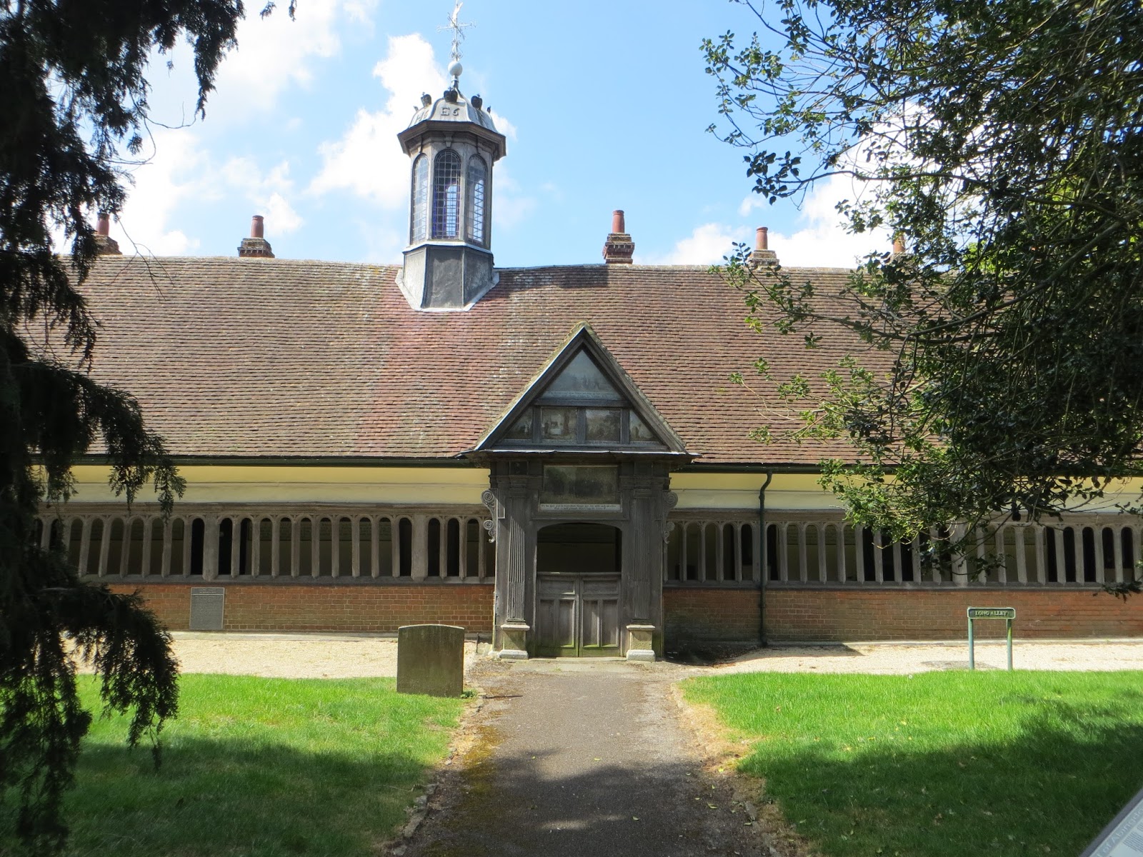
Long Alley Almshouses, St Helen's, Abingdon
Coffee break by the Thames and then a look at the old Elizabethan Alms House near St Helen's  church and then followed a delightful path, “The Ock Valley River Walk”, along the course of the river Ock, crossed the old A34 (now B4017) and across the playing fields on the flood plain of the Ock and followed the path towards to the Tesco. 

The path then headed south from New Cut Mill (SU4795 96190 - line of the old canal again) and then due south towards Drayton. The path slowly climbed upto Sutton Wick and there were reasonable views of Abingdon and its 1970s housing estates.


Sutton Wick, Drayton, was quiet and neat with various farm barn conversions. The footpath cut through from this hamlet to the village proper. This was the old part of Drayton which is not on the normal rat-run. Our path took us round the allotments, past the back of St Peters church and eventually across the B4016. It was time for lunch so we stopped at a foot bridge over a strongly flowing stream, (SU4844 9398). The water looked a bit dodgy and later investigation showed that it was the effluent from the sewage works between Drayton and Milton.


After our brief stop we headed towards Sutton Courtenay along the Drayton East Way. This is a large village strung out between the newer part in the south and the ancient village around the church. Sutton Courtenay also used to boast several pubs and now most of them are closed and converted.

Following first publication of this post our walking colleague A added the following information about the church in Sutton Courtenay.

George Orwell is buried in the churchyard of All Saints' Church, Sutton Courtenay in a rather humble grave as Eric Arthur Blair. Apparently he had no connection with the village but wanted to be buried in an English village and his friend David Astor, the publisher (son of Lady Astor, thus linked to David Cameron!) arranged it. In addition to Eric Blair and David Astor the other notable person buried in the churchyard is the Prime Minister Herbert Henry Asquith.

We detoured around the recreation ground and the back lanes and eventually came out at the George and Dragon (one of the remaining pubs), SU50494227 . We seemed to be the only people there and despite being a lovely spring day there was a fire in the grate. A welcome drink, we were quite thirsty, and then off to complete the walk by walking round the weirs at Sutton Pools and past rather quaint cottages and smart homes backing onto this back water. We came out at the new hydro power station (SU5019 9437) though couldn't tell what sort it was as it was all secure behind blank walls and steel doors.

Sutton Courtenay - a backwater


Our path went across the flood plain and up to the Culham Cut again and then to Culham Lock to collect the car and return to P's for a welcome cuppa.


Well that was good, 9.1 miles in just over four hours. Really great to discover or rediscover these villages. Sorry about the local history lecture. We feel ready to tackle the next Cross-Cotswold.

Sunday, 30 April 2017

Cross-Cotswold Pathway: Stage 7


Cirencester to Kemble Station – Friday 21 April 2017

If you are keeping note you will know that it is five months since we were last this way. Sorry about that. On the positive side, our group has increased by 25% with the A joining us at the beginning of the year. Our activities have been limited though by the usual work commitments, family duties, bouts of colds and other infections and poor weather. As reported in a recent post we have been trying to keep the joints flexed by our “training walks” with the result that we were confident that we could do this trip out to Cirencester to push on down the Cross-Cotswold Pathway.


We agreed in November that we would skip the North Cerney to Cirencester section and would start in the old Roman town of Corinivm. We joined the train at Didcot and we were speeding to Swindon when A pointed out that further down the deserted standard class carriage was Jeremy Corbyn (at the time of writing Leader of the Opposition and Leader of the Labour Party) and his team of two female advisors. No sooner had A mentioned this than the said C came up the carriage to go to the loo stopping to chat to us about where we were heading, how he had been taken around all the Roman sites when a child, etc, etc. C believed he had met A before but that might have been an ice breaker. We didn’t discuss politics nor did we seek a selfie but we were left with a good impression of a reasonable chap. As P said “he seemed like a bloke you might see down the allotments who you would lend your watering can to”. Like us C and his party got off at Swindon, us to catch the bus to Cirencester and him and his mobile-phoning assistants to be ferried off to a meeting in south Swindon.


Royal Agricultural University

That excitement over we caught the 10:20 bus to Cirencester and about an hour later set off walking from the centre of this town, Grid Ref: SP0244 0188. Cirencester was busy with market-day pedestrians including one chap who walked past us wearing jodhpurs presumably he had left his horse at the saloon. The route was a bit of a drag out along the traffic-noisy  A419 and then the A429 (Fosse Way). After about 25 minutes from town we were able to turn off and head through the grounds of the Royal Agricultural College (now University), (SP0046 0122) following the Monarch’s Way again. It was much quieter and we were able to catch up on the news and find out what N had been up to, work-wise in the Caribbean.


The weather wasn’t sunny, but not too cold, perfect for walking and we made good progress westwards, accompanied by spring bird-song and new lambs bleating, towards the line of the disused Thames and Severn Canal south of the village of Coates. Way back in 2011 we had walked along this same canal as it joined the upper Thames near Cricklade (Roman Way).


How did this get here?

We eventually joined the canal at SO9790 0004 and walked along the old tow path.
There has been much talk over the years of using the route of the canal as a way of transferring water from the relatively water rich Severn catchment into the Thames catchment with its higher water demand. The canal bed is in a pretty poor state with large trees, agricultural debris (see photo of old plough) and waste dumped into it with more than likely high seepage rates. It seems unlikely that the canal would be reinstated with that objective in mind, more likely the course could be the route of a pipeline (?)


It was the railway that did for the canal

At the GWR railway P & T were interested to see a South-West train using the line. Was this the Southampton to Cheltenham service? We will investigate the timetable when we get home.


18th Century Gothic round house

Shortly after the railway crossing of the canal we came across a “ruined 18th century Gothick (sic) canal round house”, (SO9701 0011) the purpose of which we couldn’t ascertain. There was a nearby “useful” bench so it was time for our respective picnics.


Further on the canal has been restored and is water-filled up to the eastern portal of the canal tunnel. According to the nearby information board this tunnel under the Cotswolds to the valley of the River Frome and hence the Severn. When it was built it was the longest canal tunnel in Britain, and remains the fourth longest. In the winter, when there is sufficient water depth the local conservation society offers boat trips into the first section of the canal tunnel.


Eastern portal, Thames-Severn Canal


The adjacent Tunnel House Inn (SO9656 0061) beckoned so we went and sampled the Butcombe Ale, though A had Carlsberg. The pub was rather warm inside with a large log fire so we opted to sit outside. After a while we thought it was a bit chilly and therefore time to be heading off. We rated it 6/10 though P conceded that it had nice toilets.


Thames Path starts here

To make use of public transport we needed to divert to Kemble station and retraced our route for 1.5km and then turned south on the Wysis Way (a link between Monmouth and Kemble) to join the Thames Path, in fact to the beginning of the Thames Path, (184 miles to London etc).


The source of the Thames (ST9805 9952) is marked by a large granite stone bearing poorly decipherable writing (it doesn’t come out on the photo). T remarked that granite was hardly a local stone and this large lump of igneous rock certainly intruded into the landscape (this is a geological joke.) The spring was all dried up and looked more like the site of a camper’s barbecue. We wondered how the water could flow from there to create the water course as there was no discernible channel. We plodded on across the field to Thames Head where we could imagine a better defined channel.


Thames source

Across the pastures to just to the north of the village of Kemble and then we saw the train departing for Swindon, it was 16:05; T thought the train was at 16:25! Never mind. The next train was in about an hour so we found the imaginatively named “The Tavern” pub, (ST9846 9746). We swelled the customer count by 400% and surprised the landlady by asking for four teas. Actually it was a most welcome cuppa. The bar started to fill up and it became clear that this was a favourite “watering hole” for commuters. Arkle’s ales were on offer and because of the friendly nature we rated it 7/10.


Back to the station to fiddle about getting tickets to Swindon from the machine and then the HST, that was on time. T carried on directly to Reading and A, P & N changed at Swindon for the following train to Didcot.


We will need to plan the next stage carefully, should we stick to the recommended route and the Macmillan Way and end up near Stroud or be rebellious and keep on the Monarch’s Way to Tetbury? (The later would mean a Pulham’s bus and you know what we think of them!) 

Good walking, we managed 7.7 miles. Dry and not too hot, nor too cold “Goldilocks weather”. Good to be out in the Cotswold countryside again.  Perhaps it has to be C-day, Cotswolds, Cirencester, canal tunnel and Corbyn.

Friday, 28 April 2017

Training walks (various – Spring 2017)


Sulham Woods
It has been very quiet on the Walking Middle England blog since the end of November 2016. As the festive season was approaching and the short days were impacting on the viability of getting to and from the Cross-Cotswold pathway we decided to call off the long excursions until the spring of 2017. In the meantime we decided to meet up and undertake what we have termed “Training Walks” through the winter and early spring. These are summarised below with what memories and photographs we have, (sorry no photographs in Oxford).

Industrial Oxford – Friday 30 December 2016


 Post-Christmas is always an awkward time and it is great to get out to do something other than watch old films and repeats of TV shows. Somewhere on the internet we found a suggested walk around “Industrial Oxford” this tickled our collective curiosity as an antidote to the Oxford of “dreaming spires”. Therefore on a reasonable day in late December, T, N & P met up at Oxford Station. As it turned out P had to return to Didcot and joined us later. T & N carried on and headed to the site of the Old Electric Power Station in Arthur Street, Osney. (N used to live near here when he first moved to Oxford). The 32 page guide to the walk (!) describes in some detail how coal was brought up the river to the large brick building (still there) and how local kids used to dive into the water to collect lumps of coal for the home grates. The discharge of cooling water was warm enough to allow household laundry and bathing in the river. "The station was in action for 77 years, from 1892 to 1969". We can only imagine that smoke must have drifted all across Oxford when the plant was in operation.

Osney_Mill (Wikipedia)


The route then headed down river to Osney Lock which now sports a new hydro power station (reverse Archimedean Screw). Across the river was the site of Osney Mill which had been used for a variety of milling activities over the centuries including gunpowder milling during the civil war. (More info at https://en.wikipedia.org/wiki/Osney_Mill)


We walked on along the River Thames under the railway and under the old gas works bridge. Yes Oxford had a gas works on a large 17 acre site. Here again it must have really had a detrimental impact on the quality of the air in Oxford. Both the power station and the gas works were within one mile of Carfax (centre of Oxford) and upwind of the City.


View of Oxford, from the meadows near the gas works
Before crossing the river at the old gas pipe bridge we visited the site of another of N's old addresses in a road near where Oxford Town FC used to play. The gas pipe bridge links into the 1960s development of St Ebbes that replaced the old back-to-back terraces that clustered between the gas works and the University. Part of this site is now being redeveloped again as the Westgate Centre.


Up Littlegate Street, past the Modern Art gallery, the site of one of Oxford's four breweries in Oxford and into Queen Street. One can still see the relics of an old department store and the HQ of Halls Brewery (now Top Shop).


Rejoined by P so we decided to call it a day and head to our usual “headquarters” in Broad Street only to find that it was closed for the holidays. So a few steps down the road to the junction of Broad Street and Holywell and into the Kings Arms for lunch and a few drinks, not too bad but rather busy so we were glad to leave and wish each other a Happy New Year before heading home.


Not so far, just a gentle ramble around less fashionable Oxford, 2.6 miles. Agreed we would do the rest of the walk another day!


Besselsleigh to Kingston Bagpuize  (Route 66) – 27 January 2017


As we start 2017, the news is that A, another retired colleague, has joined our band. All four of us were going to attempt the long journey out to Cirencester but illness in 50% of the party meant a change of plan was necessary. A and T met up at Oxford station and caught a Wantage bus out to Besselsleigh (Greyhound), Grid Ref: SP4600 0176. The idea was to continue our own route to Faringdon from Thame via Oxford what we fondly call “Route 66”.


Appleton church
P, N & T had started the route from Oxford to Besselsleigh on 6 March 2015 and N & T continued to lay-down the route the other side of Oxford by walking Wheatley to Oxford on 18 March 2016. As you can see from the dates this is a winter activity!


Anyhow, the weather looked reasonable as we crossed the busy A420 and passed the Greyhound pub. We took the path towards Appleton and found plenty to talk about, catching up on global water-related matters and family news. The path came out at Appleton Church and we then walked through the village, past the Plough pub (T’s parents occasionally went to this pub back in the 1950s) and then turned north-west to head slowly downhill towards the River Thames. Before reaching the river the path turned westwards to parallel the river skirting an area known as Appleton Lower Common.

Kingston Bagpuize Millennium Park
At the junction of paths (SP4201 0091) we turned south-west and slowly climbed uphill towards Netherton and then onto Fyfield (SU4222 9872). This small village used to be on the A420 but is now by-passed though traffic is still very evident from the sound of heavy trucks travelling the  Swindon to Oxford route. After carefully crossing the said “A” road we walked into Kingston Bagpuize stopping for sandwiches at their millennium park (the name rather oversells this small nature reserve).

Tree trunk art


Finished the walk at the Hinds Head, had a quiet drink and then caught the #66 bus back to Oxford.


A pleasant winter walk, not too far, 5.9 miles and not too hilly, puts us in a good position to reach Faringdon next time (next year?)


Oxford again - Friday 3 March 2017


Would we manage to complete Route 66 to Faringdon today? No it was raining. All four of us were at Oxford Station again. What to do? We agreed that we would re do the Industrial Oxford walk again for the benefit of A and P and then reassess. This we did and followed the route as described on 30 December 2016.
Oxford gasworks  1960 to 2015 (Oxford Mail)

Coffee in the Ashmolean Museum and then out across the University parks to follow the route taken on 6 November 2015. This brought us back into Broad Street, so time for a fish and chip lunch at the White Horse (HQ) having clocked up 5.3 miles in total. A very pleasant lunch and drinks and we all departed several hours later in a mellow state.


One day we will venture out into the great outdoors, we promise!


Pangbourne – Wednesday 12 April 2017


Sulham woods bluebells
P&T undertook a short training walk starting and finishing at Pangbourne station (easily accessible from their respective homes) on 12 April. This walk was based on one of 25 walks described in “Rambling for Pleasure around Reading” published by The East Berkshire Ramblers' Association.


We started from Pangbourne station walked into town past the Aston Martin/ Bentley/ Lamborghini dealership and out of town on Moors lane to cross the water meadows in the Pang valley (except they were very dry.) It was a lovely sunny day, not too hot, ideal for walking. Loads of people around; walking dogs, going to the allotments or out for a walk as it was still school holidays.  We headed south-east, crossed a small stream and joined the quiet lane to Sulham.

Yet more bluebells
Turned off and headed up hill to go into Sulham Woods. Yet more dog walkers in the woods which were now starting to display bluebells before the leaves were fully out. There were a couple of tractors racing around harrowing recently ploughed fields. More walkers as we approached Little Heath (Tilehurst).

At SU6534 7489 we turned northwards to head towards Purley-on-Thames. Great views across the recently electrified GWR, Pangbourne towards Streatley and the Goring Gap. 

View towards Streatley
As we approached Purley the path went down Beech road and then crossed the main A329 to follow an unadopted road that crossed the main railway at SU 6580 7636. We walked to the north of the railway and then at the next bridge turned north towards Westbury Farm. Impressed by a chap on a mobility scooter successfully negotiating a steep slope up onto the lane.

Hidden Westbury Farm


There was a lot of activity around Westbury Farm. There were contactors building an expensive perimeter fence, large creosoted posts, multiple wire strands, rabbit fencing buried into the ground, interplanted with laurel. As we approached the farm the public footpath was hemmed in with large Cupressus leylandii (at least 10m high). Lots of signs and CCTV cameras. Somebody wants to stay private and hide the new pylons of the railway. The work continued all the way around the farm. We turned away from the railway at SU 6448 7661 and headed towards the river and ended up eating our sandwiches at exactly the same spot , SU6452 7715, that we had a lunch break when on the Seven Shires Way on 20 June 2014.

Boze Down, Alpaca farm
A short walk into Pangbourne and stopped at the George and had an excellent pint of West Berks “Good Old Boy”. Later conversations with Pangbourne residents indicated that the George wasn't the locals choice, however we found the chap behind the bar friendly and the beer good. The word in the town (village?) is that the Jordanian owner of Westbury farm is developing a stud for Polo ponies.


A really good walk, lovely weather and always good to discover new views and perspectives, a gentle 5.7 miles.