Villages to the East of Wantage circular– Monday 23 July 2018
This walk starting and ending in Wantage was designed as a fill-in. We needed to find somewhere that was accessible without using Oxford station as there was a two-week blockade in operation. Strictly the trains were operating again on the date of the walk but by then the plan was in action. P was unable to join us. A and N arrived from Oxford (S9 bus) into Wantage market place at 10:30 and T arrived on a Thames Travel bus from Didcot a few minutes later. |
| Cottage (?) East Lockinge |
It was already hot (approx. 25C), so we set off without delay though the back streets of Wantage, past Eagles Close Almshouses (Grid Reference SU3997 8781). The first part of the walk was out along the Charlton Road heading east and then turning up Larkhill to pick up the bridleway (well used cycle path) to Lockinge. Our plan for the day was to walk through the small villages of Lockinge (West and East), the Ginges (West and East), the Hendreds (West and East) and then back to Wantage via Ardington. In view of the heat we decided to keep East Hendred for another day.
T had promised plenty of pubs but had spotted from the bus that the Plough in East Hendred (an old favourite from 40 years ago) and the Hare at West Hendred were now closed. Never mind we should be able to find somewhere in Wantage on our return.
 |
| Best Mate |
 |
| We are not race horses though |
 |
| All Saints, East Lockinge |
Further on we passed Betterton House and grounds and were surprised to see a rhino statue in the grass by the brook – now known as the Betterton Brook (it is the same stream just changes its name as it passes through each village/hamlet.) The lane continued, and we arrived in the hamlet of Ginge. Yes it is divided into West and East by of course another chalk brook this one was known as (wait for it) the Ginge Brook! Here we turned off the tarmac onto a proper footpath to head northwards to West Hendred.
We were following a variation of Walk #10 in “Walking in the Thames Valley” by Steve Davison published by Cicerone. The subtitle of the guide is “Adventurous Walking Routes”!
 |
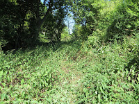
| Overgrown footpath at SU4452 8712 |
Well after struggling for about 500m we decided to abandon the “path” and head up slope to take advantage of a shady hedge (SU4452 8712) to have a snack and a drink of water.
 |
| ... and at SU4453 8677 |
A suggested that we crawl through the hedge and take a different route. Good idea - we emerged into a recently cropped hay field and carried on northwards towards the Icknield Way. Right, do we continue with "The Path to West Hendred" or divert on the Icknield Way and then a lane into West Hendred? No contest we took the latter route. We have to admit that this was the first rough, overgrown path we had come across for some time. Surprising as it was the route recommended in the booklet.
 |
| Holy Trinity, West Hendred |
We were glad of the “welcome” bench in the churchyard of Holy Trinity at West Hendred. We took time to sit in the shade and finish of our snacks. T investigated a couple of WWI war graves in the churchyard, one from 1917 and the other from 1915. Both stood erect among all the other grave stones that were all tilted at some severe angle or overgrown in long brown grass and ivy.
 |
| Ardington House |
 |
| Ardington Brook |
Our path took us through the estate buildings which have now been converted into offices for trendy hi-tech businesses and back westwards to West Lockinge.
We re-joined the path back to Wantage and after nearly 2.5 km were back into the town.
Excellent, the “Shoulder of Mutton” was open. What a relief and an opportunity to freshen up in the loo and have a much needed drink of three to quench our thirsts. We were last here on 17 April 2014 while doing the Seven Shires Way). It must score at least 8 moving towards 9 out of 10. Refreshed we headed back to the Market place for our respective buses home.
Impressive we managed 8.4 miles (13.4km) despite the heat and “jungle path”. Charming countryside and villages. No operational pubs or shops but interesting statues and lovely places to live so long as you have a vehicle.

No comments:
Post a Comment